Wednesday, January 30, 2013

Jockey Hollow cemetery: Morristown's hidden tribute to remarkable patriot troops

We haven't had a lot of snow this January, but the recent cold snap brought just a small sense of the kind of misery the Continental troops had to deal with during their encampments in Morristown during the winters of 1777 and 1779-80. Ivan and I headed to Jockey Hollow on the off chance we'd run into some of the pileated woodpeckers that are sometimes visible in the woods, and while there was just a dusting of the white stuff on the ground, the Revolutionary War soldiers weren't far from our minds.

If you grew up in Northern or Central New Jersey, there's a good chance you visited Morristown National Historical Park on a class trip. The place has a lot to capture a youngster's imagination, even aside from the obvious importance to our country's earliest days. I can recall stopping at the Wick family house to hear the legend of how the young girl Tempe hid her horse inside her family's tiny house to prevent soldiers from confiscating it. And, of course, there are a handful of huts at the edge of a clearing and atop a hill, facsimiles of the rows of rough housing soldiers built to shelter themselves from one of the harshest winters on record.

The thing we didn't notice (or weren't made aware of) on those youthful trips was the cemetery which holds the remains of over a hundred Continental soldiers who perished during those bitter months. It's easy to overlook the burial grounds, even though they're bordered by Cemetery Road. Graves aren't marked with those familiar white U.S. military stones. In fact, they're not marked at all. The only indication that people are buried there is a weathered brass plaque on a large stone, placed there by the people of Morristown on Memorial Day, 1932. That would have been about 10 months before the property became America's first National Historical Park.

While soldiers didn't have to worry about dying in battle at Morristown, they faced an equally perilous threat from disease and deprivation. The exact causes of death for the roughly 100 in the cemetery aren't clear, but it's a pretty good bet that many fell victim to the lack of supplies -- food and clothing alike -- that plagued the encampments, especially the second one. General Washington had also ordered all troops to be inoculated for smallpox during the first encampment, which no doubt led to some deaths as well.

The first national military cemeteries were created after the Civil War, so those who died at Morristown were not afforded the same honors we're familiar with today. In many cases, soldiers were buried where they fell, or, as at Jockey Hollow, were placed in mass graves. Considering the hardships they endured and the uncertainties under which they served, it seems their final resting place deserves a more prominent marker and additional attention from those who visit the park. The people of Morristown seem to have understood this when they placed the marker over 80 years ago. Their words say it all:

More than one hundred Continental soldiers who made the supreme sacrifice for American Liberty are buried in this cemetery. Their comrades were housed in huts along the Jockey Hollow Road. 

 The people of Morristown reverently erect this monument as a tribute to them and to the valor of the Continental Army whose occupancy of Jockey Hollow has hallowed this ground.


The next time you're at Jockey Hollow, stop by and pay your respects. And if you're there on a particularly cold or especially snowy day, consider how long you'd be able to endure the conditions they did, barely clothed and fighting hunger. For so many reasons, they truly deserve our thanks and admiration.


Sunday, January 27, 2013

Sugar sand and tundra swans: exploring Whitesbog

Now that we've both got our year birding lists over 100 species, we're increasing our focus on finding birds that are generally only found in New Jersey in the winter. Last weekend, the big one was the tundra swan, but Forsythe NWR, Ivan's usual no-miss site for them, is mostly out of commission as the impoundment pools are still off limits due to hurricane damage. The good news there is that the government has already started to repair the pockmarked and breached Wildlife Drive, and refuge staff expects the work to be completed by spring migration. The bad news: if tundra swans are there, you can't see 'em from the few areas of the refuge that are accessible to the public.

Still, though, we need to find the swans while they're still somewhere in New Jersey, so I reached out to the good folks at Brig for their suggestions. They recommended we try Whitesbog in Brendan Byrne State Forest. Ah, yes. Makes perfect sense: it's not all that far away, as the swan flies, and Whitesbog Village was once the state's largest cranberry producer. Cranberry growing requires bogs that are flooded over the winter to protect the plants, essentially creating shallow lakes where aquatic birds can gather. And, of course, the whole situation is a perfect Hidden New Jersey adventure, blending birding with a unique industry that many people know little about.

The General Store
Driving around the Pinelands, it's not hard to find cranberry bogs (you might recall I ran into a harvesting crew a few years back) using the industry's latest techniques. What makes Whitesbog different is that it's a step back in time. When you pull into the community, you're greeted by a clutch of small buildings and a general store, all preserved to the early 20th century, when its owner, Joseph White, was already an acknowledged leader in the cranberry industry. His daughter Elizabeth made her own mark on agriculture by successfully developing the first cultivated blueberry at the farm in 1916.

Just our luck, everything is pretty much closed up at Whitesbog during January, so we couldn't get the full experience (the Whitesbog Preservation Trust runs a series of events and tours during the year). Still, we were able to walk around and see the exteriors of some of the restored workers' houses and a few pieces of vintage equipment, and there's also a short bog trail that brings you into a small wooded area across from the general store. It was a bit, uh, soggy during our visit, and some of the boardwalks that would have gotten us over the waterier parts were out of place, so we weren't able to explore the whole thing.

Some of the workers' houses
Most important to our trip, though, the bog roads were also totally open to us. The Preservation Trust warns that visitors are taking the risks on themselves, a wise thing to consider before venturing out. You're going to be driving on berms and sugar sand that make for a sometimes pockmarked and rutted road surface, and the track is mostly only wide enough for one vehicle. These roads were intended to carry the trucks needed to maintain and harvest the crop, not to get people from one place to another. In other words, if you get stuck, you're on your own.  

Somebody in Whitesbog is a Rutgers fan!
If you go, you'll see an intersection in the middle of town with a sign denoting the bog road. Be sure to go to the right, or you'll be driving into an unending pine forest, as we did by mistake. After that detour, we got on the correct road and soon passed Elizabeth White's house, Suningive. Shortly after that, the wooded area opens up to a broad expanse of flooded bogs, which we hoped would yield flocks of tundra swans.

Except they didn't. We drove atop the berms for what felt like miles, with no birds of any kind in sight. This was supposed to be a reliable spot, yet it was completely devoid of avian life. Perhaps a little farther out? Nope. Meanwhile, we were getting farther and farther away from town, and we saw no signs guiding us to the next turn in what we thought would be a loop tour route. In Whitesbog's defense, their website directs visitors to get a map in town before hitting the road, but the visitor center and general store were closed, and the only information at the outdoor kiosk was for past events (and not a map).

You can sense a bit of our confusion in this video. (Well, I was so confused I wasn't talking straight.)


After a while, we began to wonder if we'd somehow missed a turn and ended up trespassing in someone else's bog. Regardless, we weren't seeing any tundra swans, and we'd seen enough bog to satisfy us for quite some time. The GPS would probably be totally useless in these circumstances, so we were totally on our own. "Too bad they don't have live Google Earth," Ivan lamented. Yeah, if that were the case, we'd know where the tundra swans were.

Somehow we made our way back to our starting point, but not without a few bumps and k-turns along the way. We could be extremely thankful that the gods of sugar sand smiled down on us, preventing us from being mired in a soft spot on the berms, but we were still a bit frustrated by the dearth of swans. It's been one of those months: getting some pretty unusual, rarely-seen birds while missing what are traditionally easy species to spot. In any case, I'm sure we'll get to Whitesbog again, when it's a little livelier and things are actually open.


Thursday, January 24, 2013

Palmyra Cove? It's a hoot!

We've already established that it's near impossible to find owls, even when you look really hard. Fog doesn't help much. So, then, why did we head to Palmyra Cove Nature Park on an afternoon when it was shrouded in mist so thick we couldn't see the adjacent Delaware River?

To look for owls, of course. The park is a known wintering site for saw-whet owls, which nestle within the honeysuckle canopies in the wooded areas. Given our lack of success seeing short-eared owls at Manahawkin the evening before, I think Ivan was looking for some redemption.

Palmyra Cove is easy enough to find: it's on Route 73, right at the foot of the Tacony-Palmyra Bridge leading to Philadelphia. The Burlington County Bridge Commission has reverted this former dredge-dumping site to a largely natural state, with trails extending through wooded areas, a tidal cove and a couple of small ponds. While some of the foliage consists of invasive species that typically capitalize on disturbed soil, the park attracts a nice variety of bird life, including up to 25 species of warbler during migration.

Our first stop was the visitor center to pick up a trail map and check out the exhibits, which focus on the nearby bridge and community as much as the natural environment. I was rather tickled to see that the display on the town of Palmyra included a photo of local man-who-made-good Lena Blackburn, without explanation of his contributions to baseball (one wonders whether the secret location of his baseball rubbing mud source is somewhere within the Nature Park!). There's also a pair of monitors showing a live feed of the bridge's Falcon Cam: a pair of peregrines has nested on the structure for several years. They were away from the roost while we were in the VC, but visitors are encouraged to log their sightings in a book nearby.

That exploring done, we hit the trails. Given low visibility and our desire to find owls, we chose not to take the riverside Cove Trail, favoring the path system that courses through the woods. After we passed the shallowly-filled dredge retention basin, the trail began to wind and split off at points. It didn't take long until I lost my sense of direction and got all turned around.

"I'd turn back if I were you." Fog in the woods
of Palmyra Cove.
If that wasn't enough to get me disoriented, there was the fog. It wasn't all-enveloping, but it added a certain spookiness to the whole venture. As we both scanned random vine tangles for signs of saw-whets, I couldn't help but think of the haunted forest scene from The Wizard of Oz. You know the one I'm talking about: lions and tigers and bears, oh my! I knew that the worst thing we'd come upon was a deer, but still. It was late afternoon in January, with murky weather and declining daylight.

We wandered for a good half hour, finding very little bird activity, let alone owls. I spotted a flicker high up in a bare tree, but we identified it from shape and behavior because it was little more than a silhouette to us in that light. If there were any saw-whets in the tangles of vines, they weren't letting themselves be seen.

And then... hooo! Ivan found an owl, but it wasn't the species we were looking for. Whatever it was was high up in a distant tree, far higher than a saw-whet would venture. It was something neither of us had expected to see: a great horned owl. A bit of jockeying and guidance got me onto the bird, and I probably wouldn't have noticed it even if I'd been looking that far up the tree. Perched very close to the trunk and further obscured by the fog and waning light, the owl stood motionless. I thought I could make out the pattern of its feathers, but the best identifying points were its size and the ears which stood out from its head.

So, we were zero-for-two on the small and medium-sized owls that weekend, but we scored a big one.

Monday, January 21, 2013

A quick stop at the Indian King

A trip to Haddonfield isn't complete without a visit to the Indian King Tavern, so after our find at the Elizabeth Haddon School, we headed back to Kings Highway.

You'd think that an 18th century tavern would stick out like a sore thumb in a suburban New Jersey downtown, and in most towns, you'd be right. Not in Haddonfield. The town's commitment to preserving its colonial look is so successful that we ended up heading out of town before we decided we'd gone in the wrong direction.

At least we had the right road. Kings Highway is one of the oldest throughfares in New Jersey, having been mapped between Burlington and Salem in 1686. Both towns hosted busy ports, making travel between them important, and also adding to the prestige of those communities along the road. Taverns cropped up along the way to feed and shelter travelers and, as we discovered during our visit to Rahway's Merchants and Drovers Tavern, became important forums for public discourse.

We found the Indian King's door closed when we arrived; a gentleman was clearing the front walk of leaves and told us that the museum is usually open on Fridays and Saturdays. Just our luck, though, the caretaker was on site and graciously ushered us inside, to an environment that felt very much like Merchants and Drovers. I wouldn't have been surprised to see a clutch of patriots debating the latest actions of the State Assembly, which met there on several occasions in 1777.

Because we'd dropped by unannounced, I didn't ask for the full story on the site, but what the caretaker told us whetted our appetite for a future visit. Not only was the tavern once the de-facto legislative seat, it was the site of several New Jersey government firsts, including the very first time legal documents declared us to be a state, not a colony. More recently, in 1903, the Indian King became the first historic site to be acquired by the state government.

We'll definitely be back again for the full tour, likely during one of the many events the tavern's Friends organization has slated for the year. According to the caretaker, they're finalizing the calendar now and are likely to hold open houses, a beer tasting and a July 4 reading of the Declaration of Independence. Hopefully they'll update their website as soon as the dates are set.

Friday, January 18, 2013

Elizabeth Haddon: a 21st century woman in colonial New Jersey

"There were reports of crossbills and redpolls at Elizabeth Haddon School in Haddonfield." Little did Ivan know that that innocent sentence would bring up a history lesson about a truly kick-butt woman in New Jersey history.

You might be familiar with Haddonfield (we visited last year to see the Hadrosaurus), the delightfully historic looking community in Camden County, but Elizabeth Haddon, maybe not so much.

Born in England in 1680, Elizabeth came to West Jersey at the tender age of 20. Depending on the source, she was either propelled there by her own desire to make a life in the New World, or was sent there by her father, who'd bought 500 acres of land by Cooper's Creek for reasons unknown. She was the older of two daughters, with no brothers, so if her father was inclined to send a family member to watch over his property, Elizabeth would have been his choice.

In either case, her determination served her well. Within a year, Elizabeth had started a community on the land and erected a house for herself. Comparatively well off, she entertained other Quakers who passed through on their way to Friends meetings in other parts of the region. One of these was a missionary named John Estaugh, whom she'd met several years earlier in England. It seems that she'd taken a liking to Estaugh, and he to her, enough that some have suspected he was a factor in her willingness to make such an adventurous move.

Being a man of the cloth, Estaugh lacked the financial resources the Haddons possessed, and some have surmised that he was cautious in his courting as a result. Elizabeth, however, refused to stand on tradition and proposed marriage, which he accepted. They were married in the fall of 1702, less than two years after she'd arrived.

Together, they managed the Haddon property, which grew over time through Elizabeth's father's continued purchases. He gave the newlyweds the deed to an acre of land for the construction of a Quaker meetinghouse that drew more settlers and assured the community's success. The Estaughs built later built a handsome brick house but had no children of their own, instead adopting her sister's son, Ebenezer Hopkins, to inherit their estate. Elizabeth died at the age of 82, outliving her husband by 20 years.

The town is named for Elizabeth's father (since he was the legal owner, it was Haddon's field), even though she was the driving force in its settlement. Given that the school is named in her honor, I have no doubt that the children of the community become quite aware that today's women aren't the first to make a broad and lasting impact on the world.

As for the birds, well, the crossbills and redpolls were no-shows, but we got something just as good. Perched in a backyard tree high above the rooflines was a handsome adult Cooper's hawk. He might have been the reason behind the dearth of other birds, or maybe not, but if we couldn't find the chase birds, he was a good consolation prize. Birding completed for this location, it was time to see if the Indian King Tavern was open.


Tuesday, January 15, 2013

On a road to nowhere in Manahawkin

We had a long day of ups and downs in the greater Cape May area on Saturday, looking for additions to our respective year lists and visiting the reported spots to see the more remarkable rarities that had been reported to be in the area.

As a quick update:
  • A report of a king eider hen near a jetty in Cape May Point delivered a common eider for us. (That beach spot also yielded the rare bare-rumped jaybird, but that's another story.)
  • A very yellow western tanager revealed himself after a very brief wait on a busy street corner in Cape May Court House.
  • And... after what would have been deemed a wild goose chase in other circumstances, we caught a glimpse of a crested caracara (you might remember how rare these are in New Jersey, after our story of seeing one in West Windsor last year.)
All of the roaming around left us kind of spent and ready to call it a day, but Ivan suggested one more stop as we headed back up the Parkway. Dusk wasn't far off, making it a perfect time to stop in Manahawkin to visit the short-eared owls on the marsh.

A confession: whenever Ivan mentions owling, I do a mental eyeroll, especially in pine forests where they might be tucked in broad daylight. Don't get me wrong. I love owls. In fact, our first joint birding experience was a January visit to Wallkill WMA to visit the short-eared owls. He got one in the viewing scope within a few minutes, and it accommodatingly turned to face us just as I was getting my look. Since then, it's been a lot harder to tease them out, but in Ivan's defense, owls of any ilk do their best not to be seen. Finding them takes a certain amount of luck, regardless of how advanced your birding skills are.

This time around, when I started my usual jovial owl rant, Ivan simply said, "You'll like this place. It's the road to nowhere." Say no more. Let's check it out.

We got to Route 72 as twilight was descending. A few turns brought us away from the state highway hubbub and into marsh territory. One more right turn and we were on Stafford Avenue, a lightly-traveled road occasionally marked with a pothole. "This is better than I remembered it," Ivan told me, explaining that the road is rarely maintained and can get heavily rutted and uneven a mile or so in, when it turns to hard-packed sand and dirt.

The road goes first through a forest, adding a little spookiness to the trip, but then the horizon widens to accommodate marshgrass, with no trees to obstruct the view for acres. Harriers ordinarily would have been scouting for their last meals of the day, but we saw nothing in flight. Still, the terrain was incredibly cool, as was the feeling that absolutely nobody was within shouting distance. The only real sign of human progress was the utility poles on the side of the road, though four or five of them were tilted dangerously enough to take the whole system down into the brackish water with a good gust.

Manahawkin WMA, bridge to nowhere nj
The bridge to nowhere. 
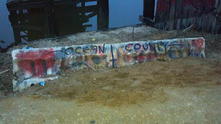
Then we got to the really cool part. The road ramped up a little before being blocked by a graffiti-laden Jersey barrier. Whoa. The car had barely stopped before I jumped out and walked up to the barrier to find remnants of an old wood bridge, its near end gone, making it impossible to walk across. It doesn't matter, anyway, as there's no road on the other side.

Manahawkin WMA, bridge to nowhere NJ"Behold!" Ivan exclaimed as he stepped out of the car. "Nowhere!" He had that right. Marsh stretched out almost as far as the eye could see, and it was so quiet, well, so quiet that any of the usual analogies about quiet were useless. That, my friends, is Manahawkin Wildlife Management Area at dusk in January.

How was I not aware of this place? I pride myself on knowing these spots, and from what I can recall, our better-known friends who cover the odder parts of the state haven't featured this Road to Nowhere. It seems that perhaps it's a secret kept by sportsmen (the state DEP maps list the area as the Manahawkin Hunting and Fishing Grounds) and birders, with the occasional spray paint-wielding local teen for good measure. I could see where the hunters and fishing enthusiasts would value the area; the marsh was sparsely crossed by old mosquito-control channels they could use to get to a blind or favorite spot.

Gazing across the marsh from one of its few (maybe only) high spots, I was again reminded of the Meadowlands -- the rickety old abandoned bridges you can see as your train rumbles along to Newark or New York, the ditches dug in the futile hopes of keeping the skeeters at bay, the wisdom of letting a certain amount of marsh just be and be natural.

As for the owls, well, they were keeping to themselves during our visit. We saw none at all before daylight finally surrendered to darkness, though Ivan thought he might have heard a short-ear bark in the distance (some say they sound like terriers). Perhaps next time.


Saturday, January 12, 2013

Yes, we have no Dracula birds... but how about a pelican?

It seems that if you want to find harlequin ducks in New Jersey, you have to work for them.

Traditionally, it's a visit to Barnegat Light -- head to the jetty in the state park and walk southward along the riprap that extends beyond the cement walk. It's like a giant video game, forcing you to step carefully from boulder to boulder without falling into the crevices between. I'm a bit more cautious than Ivan when doing this, which you can see from this photo (he's that spot on the distant right, carrying a scope on tripod).

Barnegat light jetty, New Jersey, Hidden New Jersey

Word is that the riprap-loving harlequins prefer to stay toward the south end of the jetty, requiring the arduous, cautious hike, but I'm not totally buying it. I first saw them several years ago (pre-Ivan) right at the bend in the cement walk, not all that far from the lighthouse. I remember thinking how beautiful and different they were from the standard mallard (not that I don't love the look of mallards...), and that akin to wood ducks, they look like something from a very easy paint-by-number kit.

A male harlequin duck. See what I mean?
Regardless, the harlequins haven't been in 'my' spot any of the times Ivan and I have gone to see them, so it's meant a trip down the jetty. Well, I go for a bit and then hop down to the sand on the land side, heading back up when something interesting comes along.

This time the trip looked promising: we'd already seen a nice group of oystercatchers along a distant sandbar, with a bonus seal thrown in for good measure. With any luck we'd also locate great cormorants, which have been frustratingly absent from our trips so far in 2013. Only the hike down the cement walk, over/through the railing and atop the riprap would settle it.

And.... yes. The harlequins were as reliable as ever, swimming busily along the jetty, some actually leaving the water to perch on the rocks. A few loons swam about, as did one constantly-diving razorbill, probably the closest avian visitor New Jersey has to the penguin. But... the cormorants were totally absent. What gives? Perhaps with their Dracula-like wing drying posture, they're in witness protection? At the very least, they're playing a pretty frustrating game of hide-and-seek with us.

Still, when nature denies, she inevitably provides a pretty cool substitute. As we continued our scan, a brown pelican glided north over the inlet at about eye level, unmistakable in size and silhouette. A pelican? Now? In New Jersey? Given everything we've seen visit the state over the past year, a late-staying pelican seems like par for the course. One more bird for my state list, and a very early addition for 2013.


Wednesday, January 9, 2013

Sabotage and bravery at Lyndhurst: the 1917 Kingsland explosion

One of the best pieces of exploring advice I ever got was to stop and turn around once in a while. The idea was that while you'd seen where you'd been, it was from one direction. Reversing course occasionally will give you a whole new perspective.

Kingsland explosion, Tessie McNamara Park, Lyndhurst NJ, meadowlandsI was reminded of this advice on a recent roam around the Meadowlands. After finding DeKorte Park was closed, I headed back toward Route 3, making a quick detour down Clay Avenue in Lyndhurst to check one of Ivan's little birding spots. There's a small marshy pond amid the office buildings and warehouses, with some of the usual detritus you expect in an area that's gone between natural and industrialized (and sometimes even dumped on) over the past two centuries. While it rarely seems to produce much in terms of avian life, I was in the area, so what the heck.

Usually we approach from the north and pull into an adjoining parking lot. This time I was coming from the south and found something I hadn't noticed before. Next to the small viewing platform was a plaque on a rock, or as it's known to us, potential Hidden New Jersey gold. Even better, there was lots of text on it, and a line drawing of a woman. Was she the person who'd fought for the preservation of this little oasis of wetland among the macadam and brick?

No, she wasn't, but as it turns out, she'd preserved much more than that. Tessie McNamara was the heroine of the 1917 Kingsland Explosion, and our little bird spot was once the site of the Canadian Car and Foundry munitions plant. As the plaque tells it, Tessie was the company's first female employee and the plant's switchboard operator. When a fire broke out in the factory on January 11, 1917, the 25 year old bravely stayed on duty, alerting employees in all 40 buildings in the complex as well as the fire and police departments. "My first thought was to save the lives of the 1700 men in the buildings," the plaque quotes her as saying. "While making my calls, the first shell struck the building and passed about five feet from where I was sitting. About a dozen buildings were now on fire, and I had completed all calls. I started to leave the building without a coat, but I couldn't walk. My courage left me and the arriving firemen picked me up, wrapped a big coat around me and rushed for the gate."

What the plaque doesn't say is that the Kingsland Explosion was most likely an act of sabotage perpetrated by German spies. The United States hadn't yet entered World War I but was, nonetheless, supplying munitions to Great Britain and Russia. Canadian Car and Foundry produced 3 million shells per month, making it a suitable target. Security was tight, so to get entry into the factory without raising suspicion, the saboteurs got jobs with the company and planned to make damage with materials they could find within the building. It wasn't exactly a difficult task, it seems: the manufacturing process used either alcohol or gasoline to clean out the shells, so several workers had flammable liquids at their workbenches.

During the incident investigation, witnesses noted that the blaze had started at the workstation of one employee who'd seemed especially nervous that day. He reportedly had more that the customary number of cleaning rags and had spilled his pan of alcohol just before the fire broke out. Before the authorities could question him, however, he disappeared.

Kingsland explosion, WWI sabotage, Tessie McNamara, Canadian Car and Foundry, Lyndhurst NJ
Just above the center of this photo, you can see
a smokestack, the last visible portion of the factory.
Whatever the cause, the fire completely destroyed the 40-acre factory complex and damaged several houses up the hill, with an estimated half-million shells exploding like fireworks over a four hour period. Like the Black Tom Wharf explosion in Jersey City six months earlier, the Kingsland conflagration was a stunning sight to those in the skyscrapers of Manhattan ten miles away. It's also said that patients in the asylum on Snake Hill were deeply disturbed by the explosions, thinking them to be a sign of the end of the world.

Today, very little is left of the Canadian Car and Foundry complex -- just a portion of a smokestack sticking out of the marshy pond. Mallards and coots swam past it on my latest visit, unaware of the site's violent past. As for Tessie McNamara, she was the Captain Sully Sullenberger of her day, thrust into the public consciousness for using her vocational skills to save others. She gained momentary fame as newspapers around the country hailed her heroism and levelheadedness. The National Special Aid Society, an emergency preparedness organization founded on the eve of World War I also gave her a monetary award. Preferring a quiet life, she quickly shunned the spotlight and presumably found another office job. She later moved from Lyndhurst to East Rutherford, where she died in 1971. I wonder if she ever returned to the scene of her heroism.

Sunday, January 6, 2013

From Ellis Island to the rest of America

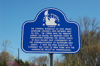
I love running into signs like this:


Ellis Island, Jersey Central Railroad, Bloomsbury, NJ

Where is it, you wonder? Jersey City? Newark? Nope. It's in Bloomsbury, 60 miles west of the historic Immigration Station at Ellis Island. I was a bit taken aback, but not surprised, to find this marker on a ramble through Warren County. It kind of pops up out of nowhere, next to what was once a railroad right of way.

Visitors to Ellis Island learn about the arduous ocean passage that immigrants took in the late 19th and early 20th centuries, enduring cramped and often unsanitary conditions in steerage. There's talk about the post-inspection ferry ride to Manhattan or the Jersey Central rail terminal in nearby Communipaw Cove, but little to nothing is shared about what happened next.

All together, about 70 percent of the people who went through Ellis Island between 1892 and 1924 ultimately settled someplace outside New York City, so the demand for train passage was intense. Immigrants forged yet another link of what might be a lengthy journey to their final destination, perhaps several train transfers westward. Held in a separate room at the Jersey Central terminal until their trains were called, the new arrivals were often put into designated cars to separate them from the American travelers.

Finding this sign so far from Ellis gave me pause. As I stood at the roadside, so close to the path of the immigrant trains, I couldn't help but compare it to the wagon train paths that brought homesteaders westward to new claims and new lives in the 1800s. I wondered what the immigrants were thinking as they passed that very spot on their way to their new homes. Did America look the way they expected it would? Were they satisfied so far, or disappointed? Were they relieved to be on the train, past the inquisitive eyes of the government inspectors? Were they frustrated by the prospect of another long, tiring trip? Their feelings might be hidden in family stories or letters tucked in attics, or perhaps never shared at all.


Thursday, January 3, 2013

Safety Follows Wisdom in Alpha

It's a January 1 tradition with us: get up early (yes, early), head out to a targeted spot and find as many birds as possible to start off a brand new year list. This time around, we started the search in Warren County, since Ivan anticipated that foraging snow buntings would be easily visible on some of the farm fields near Carpentersville. The snow cover presumably would force the flock to concentrate toward the cleared edges of the road rather than spreading out over a broad expanse of farm fields. Plus, we could also stop by Round Valley, Spruce Run and Merrill Creek for waterfowl and various wintering songbirds. Somewhere in the mix, there'd be something else of note; I didn't know what, but I was confident.

The farms offered a bit of a mixed bag. While we found a big flock of horned larks near the side of the road and snow geese overhead, buntings were frustratingly absent, and nary a kestrel was patrolling the fields. Chalking the results up to the unpredictability of nature, we went on our way, with a detour to grab some coffee and fill the tank.

We've been to the area plenty of times, but it was the first time we've stopped in the small commercial area of Alpha, so I had an eye out for the new and unusual. The roadside didn't disappoint. Not far away from the Quick Chek, we passed a large stone slab, about seven feet tall, standing proudly at a street corner. It looked kind of dampish in places, the way concrete tends to when there's been precipitation recently, but I could make out some lettering beneath a relief sculpture and the legend "Safety Follows Wisdom." Bingo! We pulled over and I jumped out to investigate.

Closer inspection revealed that the marker was an award recognizing Vulcanite Portland Cement Company for a perfect worker safety record in 1930. Only thing was, the Vulcanite Company was nowhere to be seen. Had the award outlived the business? And what was the origin of the award? We'd found a nice little research project.

We already knew that Warren County was a good location for cement companies, due to the availability of good quality lime, a core component of the building product. You'll recall that Thomas Edison's Portland Cement plant operated in nearby New Village, and there's a big cluster of lime kilns in the area, too. Large open-pit quarries reached the mineral easily and inexpensively, making the industry a natural for the location. Edison, in fact, was so high on the potential of cement that he envisioned entire communities of concrete houses built cheaply for working class families. His company and Vulcanite were the two major cement manufacturers in New Jersey.

The big cement slab of Alpha is anchored in the early days of the worker safety movement. Starting in 1912 and well before the enactment of the Occupational Health and Safety Act, the Portland Cement Manufacturing Association began tracking on-the-job accidents and fatalities within its members' plants. This led to the creation of programs to encourage worker safety, and eventually to the establishment of an industry award for the plant with the best record in a given year.

For the first several years of the program, winning plants received a trophy to be held until the next awardee was announced, but presumably this wasn't enough to publicly represent the industry's commitment. Something bigger, more permanent could be placed outside the plant gate to remind workers of their achievement and prompt them to keep the safety culture going. The association held a competition for the design of a larger, more permanent and more public monument to be displayed by plants that operated accident-free for a full year. Fittingly, it was to be cast in concrete, with room to recognize subsequent achievements.

The winning design was created by a group of students from the Art Institute of Chicago, with guidance from noted sculptor Albin Polasek. The character on the right is meant to represent Athena, goddess of wisdom, with a lamp to illuminate the path forward for the male figure personifying safety.

The first such monument was awarded in 1924, with the last presented sometime in the 1980s when it was deemed too expensive to hand out seven-foot tall concrete slabs on an annual basis. Google search reveals dozens of nearly identical monuments all around the country, in many places abandoned with the shells of the factories whose employees earned them. The Portland Cement Association still recognizes excellence in safety, but with a much smaller token of esteem.

The Vulcanite company opened in 1894 and appears to have ceased operation in 1941, leaving its monument behind. This would be consistent with the fate of the Edison Portland Cement Company, which closed in 1937 and was dismantled in 1942, a victim of resource shortage. The area's more accessible limestone deposits were being rapidly depleted, leaving only underground deposits that would require expensive shaft mining to extract.

Today, New Jersey has no cement manufacturers, but the work of countless plant workers is memorialized in the durability of the structures cast from their product... and the trophy that stands as testament to their commitment to safety.