Several years ago, my work took me to Lower Alloways Creek from time to time, bringing me past the Colonial-era Hancock House. What I was doing in a remote part of Salem County is a story for another day. The important thing to note is that every time I went past, the house was closed, leaving me with unsatisfied curiosity.
Hancock House is more than a nearly-300-year-old house whose bricks are laid in interesting patterns. It was the site of a March 1778 massacre. When Ivan brought up the possibility of spending a day at the Delaware bayshore last weekend, I suggested that we make a visit to the Hancock. Maybe it would even be open this time.
Before we get into our trip, let's talk about the massacre. Just a few days earlier, the Americans had taken the surrounding area after the battle of Quinton Bridge, about 90 Continentals were quartered at the Hancock House. The home's owner, William Hancock, was a judge and a Tory, and he'd left the area once the American forces achieved dominance. However, he returned on March 20 and was quickly taken captive.
All were asleep when a raiding party of 200 British soldiers attacked the house early the next morning. Many of the Americans were bayonetted in their sleep; others pled in vain to be taken prisoner. A precious few were able to escape, but ironically, Hancock himself was murdered by the loyalists with whom he agreed.
The house is now owned by the State of New Jersey and run by local volunteers. I'd actually stumbled upon the house being open on a March day many years ago, and found the guides to be very friendly and knowledgeable. In fact, before I left that day, they implored me to come back few weeks later for a reenactment. "You'll really like the massacre," they told me. "It's a lot of fun!"
We weren't as lucky with the latest visit, though I'd checked the website in advance for operating hours. A sign outside the house said the volunteer staff was at a street fair in Salem City, so no one was around to show us the interior. Even if you have the same luck we did, however, there's lots to see around the property. The site's interpreters probably realized that a fair number of visitors would happen by when no-one was there to tell the story, so they developed really good signage.
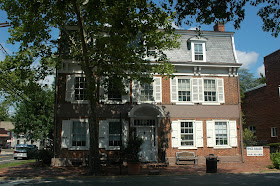
The house exterior is the logical first thing to check out, but it's not exactly obvious since it's on the side not facing a street. The patterned end brickwork contains both a zigzag pattern and the initials of the house's owners, William and Sarah Hancock, along with 1734, the year it was built. Overall, the architecture reflects the English/Quaker influence of the European settlers in that part of New Jersey. Salem County is second to only Burlington County in the country when it comes to the number of surviving brick houses with pattern designs.
Next, there's a Swedish plank cabin on the property. This building itself was built in 1931 by the Civil Works Administration with 400 year old cedar mined from property in Salem. All of the craftsmanship is authentic to the 1700s, meaning it would look very familiar to the Swedes who settled in the area during Colonial times. An informative wayside offers all the information you'd probably want to know about the cabin.
We also took a few minutes to check out the creek that meanders in front of the house. While there was no real wildlife to be seen, I don't doubt that the occasional muskrat makes its way through, along with various waterfowl. Yet another marker explains that PSE&G has been doing mitigation work to encourage the growth of water life in consideration for the operation of its nuclear plant a few miles away.
Satisfied we'd learned as much about Hancock House as we could expect that day, we set course for our next destination. We'd learned about a massacre that didn't occur in Boston... how about a tea party that didn't happen in Boston, either? Off we went, traversing the back roads to Greenwich.
The travels and adventures of a couple of nuts wandering around New Jersey, looking for history, birds and other stuff.
Pages
▼
Wednesday, August 29, 2012
Sunday, August 26, 2012
Unfazed by Shark Week? Give Heron Week a try.
Discovery Channel has Shark Week.
Hidden New Jersey had Heron Week.
Okay, it doesn't have the same menacing bite or blood-curdling suspense, and we didn't need to protect ourselves with a cage, but our bird week had the element of surprise and even a fun new dance step.
Followers of our Facebook page already know about our first three episodes. I'm going to cheat a little and start on August 15, when I got a view of the tricolor heron that's been hanging around DeKorte Park in Lyndhurst. Reasonably rare for New Jersey, he was hanging out among some terns, perched in the open on a railing along the Marsh Discovery Trail. (Many thanks to the Meadowlands Commission's Jim Wright for setting me on course!)
Last Wednesday, I had a three-heron day at Echo Lake Park in Mountainside. The lower lake segment yielded a not-unexpected great blue heron along with a curfew-busting black-crowned night heron. The nice surprise for me there was the presence of not one, but two green herons. While they're not tremendously rare, they're not exactly an everyday occurrence, and I was glad to have found and identified them on my own.
The next day I returned to Echo Lake with my camera, hoping to get a shot of the green heron, but he'd already moved on. Just as well, as I located one (maybe even the same guy) at adjacent Lenape Park in Cranford. A subsequent trip to Surprise Lake in Watchung Reservation yielded yet another greenie, not far from another great blue.
Later that afternoon, a check of the American Bird Association bulletin boards revealed big news: a reddish egret was spotted at one of our regular birding destinations, Forsythe NWR (a.k.a. Brig). This was significant. I'd never seen one, and the range map in the Sibley guide showed it as a rare visitor to the Eastern Seaboard. Just as important, the guide described the bird as "very active, chasing fish on foot, running, jumping and spinning." This I had to see: the Bird Minister of Silly Walks. Check out this video for a sample, and tell me you wouldn't want to check it out, too. There's something very appealing about watching a bird that looks like a drunken frat boy hunting for his lost keys.
Ivan and I decided that waiting for the weekend was not an option. If reports in the morning said that the bird was still at the refuge, we were making the trip to see it. All egrets, of course, are herons, so a chase for the reddish egret would fit perfectly into our theme week.
Friday morning dawned, bringing with it news of the bird still in its reported area at Brig. After getting some non-birding activities out of the way, we hopped on the Parkway, hoping the shore traffic hadn't started yet. We ran into some frustrating construction delays but told each other that if fate deemed the bird would leave before we got to him, we'd accept it.
Once we got to the refuge, we blew off the usual first stops and went directly to the eight-mile loop road through the marsh. Thursday's reports had the bird at the dogleg turn about three-quarters down the road, but a crowd of cars and birders were clustered about a mile or two into the drive. If this wasn't the egret, it was definitely something worth seeing.
Ivan pulled up to a couple of the gathered birders and rolled down the window to ask if it was the reddish egret. Yup.
"I thought it was at the dogleg."
The other birder shrugged. "It has wings."
Our quarry was roosted in a distant cedar tree, along with a couple of snowy egrets. Apparently he'd already eaten, because he seemed more interested in preening than in jumping down and doing the runaround dance. Or perhaps we'd just timed it badly and had to wait for the next show. In any case, his staying put allowed us to get a good view through the scope, enough of a study to feel that we could add the reddish egret to our New Jersey birding lists. And besides, though the bird didn't seem to want lunch, we humans were famished. We'd head over to JD's for a burger and return to see what else Brig had to offer us that day.
Our hunger eliminated, we returned to the refuge, this time making our usual stops before embarking on the loop road. A stop near the gull pond produced a view of easily a dozen great egrets perched in a tree, along with assorted others wading about. In the time since we'd left, however, the tide had rolled in, displacing many of the shorebirds that had been walking around the mudflats on our earlier visit. Maybe this wouldn't be such a productive visit, after all.
A new set of birders were perched and focused at the same spot in the road as we'd been with the earlier crowd, and for good reason. Perhaps encouraged by a higher water level, the reddish egret had come down from his perch to forage for fish. We stopped again, pulled out the viewing scope and were rewarded with the sight of him pacing around the shallows. Apparently a juvenile, he didn't seem to have the silly walk down pat, but he was entertaining to watch, nonetheless. Seeing that performance, I was satisfied to have gotten a good view of a creature I might never be in the presence of again, at least not in the Garden State.
That would have been a great ending to Heron Week, but our luck continued the following day when we visited Salem County. Driving through the countryside enroute to Hancock's Bridge, we passed the inevitable cattle and... the accompanying cattle egrets. Ten of them were patrolling the pasture, some close to the cattle and others a little on their own. Not as improbable to New Jersey as the reddish egret, it was still a nice find for us.
Heron Week aside, we've been very fortunate to see some rare and wonderful avian visitors to New Jersey over the past year. Whether it's due to global warming or just an odd coincidence for them to find their way here, I'm grateful that places exist for them to rest, find food and seek refuge. Who knows what's in store for next year's Heron Week?
Hidden New Jersey had Heron Week.
Okay, it doesn't have the same menacing bite or blood-curdling suspense, and we didn't need to protect ourselves with a cage, but our bird week had the element of surprise and even a fun new dance step.
This tricolor heron has been hanging around the Meadowlands for a couple of weeks. |
Last Wednesday, I had a three-heron day at Echo Lake Park in Mountainside. The lower lake segment yielded a not-unexpected great blue heron along with a curfew-busting black-crowned night heron. The nice surprise for me there was the presence of not one, but two green herons. While they're not tremendously rare, they're not exactly an everyday occurrence, and I was glad to have found and identified them on my own.
Green herons really seem to like Union County parks in August. |
Later that afternoon, a check of the American Bird Association bulletin boards revealed big news: a reddish egret was spotted at one of our regular birding destinations, Forsythe NWR (a.k.a. Brig). This was significant. I'd never seen one, and the range map in the Sibley guide showed it as a rare visitor to the Eastern Seaboard. Just as important, the guide described the bird as "very active, chasing fish on foot, running, jumping and spinning." This I had to see: the Bird Minister of Silly Walks. Check out this video for a sample, and tell me you wouldn't want to check it out, too. There's something very appealing about watching a bird that looks like a drunken frat boy hunting for his lost keys.
Ivan and I decided that waiting for the weekend was not an option. If reports in the morning said that the bird was still at the refuge, we were making the trip to see it. All egrets, of course, are herons, so a chase for the reddish egret would fit perfectly into our theme week.
Friday morning dawned, bringing with it news of the bird still in its reported area at Brig. After getting some non-birding activities out of the way, we hopped on the Parkway, hoping the shore traffic hadn't started yet. We ran into some frustrating construction delays but told each other that if fate deemed the bird would leave before we got to him, we'd accept it.
Once we got to the refuge, we blew off the usual first stops and went directly to the eight-mile loop road through the marsh. Thursday's reports had the bird at the dogleg turn about three-quarters down the road, but a crowd of cars and birders were clustered about a mile or two into the drive. If this wasn't the egret, it was definitely something worth seeing.
Ivan pulled up to a couple of the gathered birders and rolled down the window to ask if it was the reddish egret. Yup.
"I thought it was at the dogleg."
The other birder shrugged. "It has wings."
Our quarry was roosted in a distant cedar tree, along with a couple of snowy egrets. Apparently he'd already eaten, because he seemed more interested in preening than in jumping down and doing the runaround dance. Or perhaps we'd just timed it badly and had to wait for the next show. In any case, his staying put allowed us to get a good view through the scope, enough of a study to feel that we could add the reddish egret to our New Jersey birding lists. And besides, though the bird didn't seem to want lunch, we humans were famished. We'd head over to JD's for a burger and return to see what else Brig had to offer us that day.
Our hunger eliminated, we returned to the refuge, this time making our usual stops before embarking on the loop road. A stop near the gull pond produced a view of easily a dozen great egrets perched in a tree, along with assorted others wading about. In the time since we'd left, however, the tide had rolled in, displacing many of the shorebirds that had been walking around the mudflats on our earlier visit. Maybe this wouldn't be such a productive visit, after all.
A new set of birders were perched and focused at the same spot in the road as we'd been with the earlier crowd, and for good reason. Perhaps encouraged by a higher water level, the reddish egret had come down from his perch to forage for fish. We stopped again, pulled out the viewing scope and were rewarded with the sight of him pacing around the shallows. Apparently a juvenile, he didn't seem to have the silly walk down pat, but he was entertaining to watch, nonetheless. Seeing that performance, I was satisfied to have gotten a good view of a creature I might never be in the presence of again, at least not in the Garden State.
That would have been a great ending to Heron Week, but our luck continued the following day when we visited Salem County. Driving through the countryside enroute to Hancock's Bridge, we passed the inevitable cattle and... the accompanying cattle egrets. Ten of them were patrolling the pasture, some close to the cattle and others a little on their own. Not as improbable to New Jersey as the reddish egret, it was still a nice find for us.
Heron Week aside, we've been very fortunate to see some rare and wonderful avian visitors to New Jersey over the past year. Whether it's due to global warming or just an odd coincidence for them to find their way here, I'm grateful that places exist for them to rest, find food and seek refuge. Who knows what's in store for next year's Heron Week?
Friday, August 24, 2012
Visiting the almost town of Aeolia
Take a good look at a map of New Jersey's towns and cities, and you'll see the names of once mighty companies that built them or were the dominant employer.
Somerset County's Manville was once home to Johns Manville's massive asbestos processing operation.
Roebling, in Burlington County, was built to house employees of John A. Roebling's Sons and Company, manufacturers of the steel rope that still supports mighty bridges across America.
Helmetta was built around George Helme's snuff factory in Middlesex County.
And then there's Aeolia, in Union County.
Aeolia? Okay, I fudged that one. You might recognize it as Garwood, smack between Cranford and Westfield. The only indication left of the little-known alternative name is the header atop the entrance to the crenelated red brick building on North Avenue. Workers in this century-old building once made pipe organs, player pianos and perforated music rolls for the Aeolian Company, the leader in its industry.
These days, player pianos are a rare novelty, but apparently they were huge in the early days of the 20th century. A 1899 New York Times article stated that Aeolian became the sole player piano company in the United States after absorbing two of its competitors. The company consolidated operations at a new plant in Garwood, built along the Jersey Central Railroad line. As a condition of moving to New Jersey, the article said, the company had the option of naming the town Aeolia.
It's an interesting statement, given that Garwood wasn't even an incorporated town at that point. Rather, it was a real estate development the railroad had carved from the towns of Westfield and Cranford. Named for Samuel Garwood, president of the development company, the community was largely industrial, with Hall Signal Company and Hercules Tube Works being the major employers before Aeolian came to town.
Garwood was a tight-knit, working class community, but its uncertain status caused a fair bit of confusion. According to the town's website, Westfield and Cranford often disagreed over which town was responsible for providing essential services within the less than mile-square enclave. Which school system would Garwood students attend? Who was responsible for paving Center Street through the business district? The Aeolian Company settled the matter of fire protection by forming its own squad and buying equipment.
Most of the issues were resolved when the roughly 400 Garwood citizens achieved independence from their squabbling neighbor towns in 1903. It's an interesting thing to consider these days, as consolidation of municipal services is frequently raised as a cost-cutting alternative to the status quo. For the residents of the newly incorporated Garwood, however, it made a huge difference in solidifying what they could expect from their local government.
Over a hundred years later, much of Garwood's industry has left, and many of the old factory buildings have been torn down or repurposed as retail space. The office section of the Aeolian building still looks neat and manicured, though the factory portions could use some help. For a while, a paperboard recycler operated there, but in recent years the place has looked unused. Whatever becomes of the property, I hope they keep the brick building and the Aeolian sign above the main entrance.
Tuesday, August 21, 2012
Milling around in Stillwater, generally speaking
Our visit to White Lake built up a thirst, so we found ourselves wandering in search of liquid refreshment. We found it at the general store in Stillwater.
If you've done any wandering through the less built-up areas of the state, you've probably run into a historic general store building or two. I say 'historic' because many of them don't serve the 'general' purpose anymore. Instead of selling various groceries and housing the community post office, they've been converted into gourmet sandwich shops or coffee houses. There's nothing patently wrong with that -- repurposing buildings is often the best way to preserve them -- but they lack a certain authenticity. They often sell fair-trade coffee by the pound instead of penny nails, and if you need toilet paper or soap you'd better be prepared to drive a distance to a big-box store.
The minute we pulled up to the Stillwater General Store, it was clear which category it falls into. An out-of-service Texaco Fire Chief gas pump stood in front of the porch, paired with one of those vintage advertising signs. Both came by their weathered appearance honestly, as did the screen door that had clearly welcomed generations of local residents. Once inside, we passed a wall of post office boxes on the way to the beverage cooler. To be honest, I was so focused on getting something to drink that I didn't study the groceries on the shelves, but it wouldn't be an exaggeration to say that they probably focus on the bare necessities someone might need when a trip to a distant supermarket was out of the question. Oh, and when we made our purchase, the proprietor said something about pie. I'm still regretting passing that up. I mean, Sussex County pie must be really good.
Our thirst issue resolved, we noticed that the general store wasn't the only interesting building in town. A short walk brought us to the home of Casper Shafer, the German immigrant who'd settled the area in the early 1740s. While the Vass family was growing grain in Hardwick, Shafer ran a successful grist mill that was paired with a sawmill just before the Revolution. In addition to counting on the nearby Paulins Kill to power his mills, he used the waterway as means to get his product to the Delaware and eventually to customers as far away as Philadelphia.
Shafer's wooden mill was destroyed by a fire in 1844, but its replacement still stands nearby, looking as if it could be transplanted to an old village in the Alps. In fact, it looks a little too good, as if it shut down just a few years ago. Actually, in the continuum of milling in New Jersey, that's the case. Its continuous operation ended in 1954, but new owners reopened it in the early 1970s, running it as a milling business during the week and an educational establishment on the weekends.
It's not clear when the Stillwater shut down for good, but when it did, it was the last of New Jersey's operating grist mills. The industry had fallen victim to development, as more grain farms were sold and converted to residential communities.
Somehow, Stillwater seems to have avoided overdevelopment, or at least the area around Main Street has. On our Sunday visit it was quiet, except for the steady flow of visitors to the general store. There were an assortment of other buildings we didn't check out... the church on the hill and the historical society, to name two. Maybe another time, when we'll be sure to stop for the pie.
Stillwater General Store always seems to have someone parked directly in front of it. |
Our thirst issue resolved, we noticed that the general store wasn't the only interesting building in town. A short walk brought us to the home of Casper Shafer, the German immigrant who'd settled the area in the early 1740s. While the Vass family was growing grain in Hardwick, Shafer ran a successful grist mill that was paired with a sawmill just before the Revolution. In addition to counting on the nearby Paulins Kill to power his mills, he used the waterway as means to get his product to the Delaware and eventually to customers as far away as Philadelphia.
The Stillwater Mill, looking a lot like one of those cute figurines people collect. |
It's not clear when the Stillwater shut down for good, but when it did, it was the last of New Jersey's operating grist mills. The industry had fallen victim to development, as more grain farms were sold and converted to residential communities.
Somehow, Stillwater seems to have avoided overdevelopment, or at least the area around Main Street has. On our Sunday visit it was quiet, except for the steady flow of visitors to the general store. There were an assortment of other buildings we didn't check out... the church on the hill and the historical society, to name two. Maybe another time, when we'll be sure to stop for the pie.
Saturday, August 18, 2012
White Lake: nature overtaking history and industry
The appearance of a misplaced brown booby brought Ivan to White Lake in Hardwick a few weeks ago, and when he told me about the location, I knew I had to check it out, too. By the time we went together, the booby had already moved on, but the trip was definitely still worth it.
Just a few hundred feet off County Road 521 (Stillwater Road), the spring-fed lake is fronted by a lovely field of wildflowers that likely yield a nice assortment of butterflies. Parking is easy, as is the walk to the lake's edge, offering unusually quick access to a true hidden gem. Several people were lifting kayaks out of the water just as we arrived; it looked like a nice, calm place to do some leisurely rowing. If I were artistically gifted, I'd be inclined to bring out an easel and paint the landscape. Bob Ross, where are you and the happy little trees?
Managed by Warren County and the State Division of Fish and Wildlife, the White Lake Natural Resource Area contains several habitats, including a hemlock forest and a boggy fen at one edge of the water. However, the property hasn't always been allowed to exist as a pastoral area. The most visible sign of that is the stone farmhouse and wooden barn just across the road; the other indications of man's interference have apparently been overtaken and obscured by nature.
The Vass farmstead dates to the earliest days of the 19th century, home and workplace to German immigrant John Vass and his family. They expanded the farm through acquisition over the years, growing a variety of grains and apples while also raising livestock for sale. Living at first in a log cabin, the success of the farm enabled them to build the sizable stone house overlooking the pond.
After John's death in the 1850s, son Isaac took over the family business, eventually selling some of the land on the far side of the lake to the Knickerbocker Ice Company of Pennsylvania. Ice, however, was only part of the reason the company sought the property. During the warmer months, it mined the water's bottom for the shells which gave White Lake its name. The mineral content of the shells was used first as a marl fertilizer, and then as an essential component in the production of cement. When the region's ice industry was essentially overtaken by more efficient competitors to the west, Knickerbocker withdrew from the lake, replaced by other companies with greater interest in marl and cement production. Their business was short-lived, marked by the scandal of a partner's thievery, and the lake was apparently never mined again.
Today, the only indication of the Knickerbocker company's activity at White Lake is a large stone structure which was once the largest building in the area. Used as a warehouse for ice or marl, depending on the season, it's now barely noticeable from the farmstead side of the lake. We didn't even see it while we were there, though I suppose it might be more visible after the summer foliage fades away in the fall and winter.
Now 200 years old, the stone farmhouse is being restored through the cooperative efforts of the Hardwick Township Historical Society, Warren County Freeholders, the New Jersey Office of Historic Preservation and others. It wasn't open while we were there, but the adjacent partially-restored barn was hosting a fundraiser to support the effort. Beyond the usual garage sale wares, the upper portion of the barn offered an assortment of old farm stuff and a neat two-wheeled horse cart. I even noticed an old wooden hay rake, the type that angry mobs of townfolk found so useful in fending off monsters in the old Frankenstein and Dracula movies. (Torchlike implements, however, were nowhere to be found.)
More important to us, the sale gave us a chance to get an overhead view into the not-yet restored part of the barn that apparently housed dairy stock. The echoing moos are but a distant memory, but it seems that the property is reverting to a state that John Vass and his family would recognize quite well.
Wednesday, August 15, 2012
Way too big to misplace (but we did): hunting for the Paulinskill Viaduct
Sometimes it pays to keep old stuff in the car. You never know when you'll need it.
Longtime Hidden New Jersey readers know that we count on a few key reference materials during and after our forays into the field. Ivan's got his birding manuals, and my bible, of sorts, is the WPA Guide to 1930s New Jersey. You know there's potential for a good story if you locate something that was listed in a travel guide more than 70 years ago.
That's especially true in Northwestern New Jersey, where a lot of stuff is still where it was back then. We were counting on that when we stopped near Andover-Aeroflex Airport the other day to get our bearings. While Ivan did some light birding, I checked the WPA Guide for the next destination.
Bingo. I found "the Lackawanna RR Cutoff, 110 feet high and stretching for three miles across Pequest Valley. Built just prior to the World War, it helped to reduce the main line distance by 11 miles."
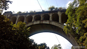
That, I was pretty sure, referred to a portion of the Paulinskill Viaduct, a well-known but well-hidden engineering marvel of its day. With soaring arches supporting the rail line between Hoboken and Scranton, it was, at its construction in 1911, the largest structure built using cast concrete. It hasn't supported train traffic since 1984, but it's gained a fan base among urban explorers. And, well, it's historic. I'd been there before, but Ivan hadn't, so it was worth a look. The thing is massive, and it comes out of nowhere, like a mirage in the woods.
My recollection was that it was just off one of the north-south roads north of Route 80, but I couldn't remember if it was 206 (which we were on) or 94. We decided to find out. The Guide said there was something there, so what the heck.
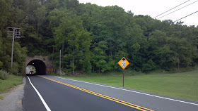
Only thing was, we couldn't find it. Somewhere around the prescribed mileage, we found a side road that turned and paralleled 206, so we took that. Nothing approaching the magnitude of the Viaduct appeared. Frustrated, Ivan did some backroads driving until the road took a tunnel through what appeared to be a very large hill. This is what we saw on the other side:
I have to admit that my favorite part of the whole story is where the school got buried during construction and the kids cheered.
The sign confirmed what the Guide had told us, but it indicated nothing about the viaduct. It wasn't easy to see where the cutoff headed, or where the track had been, because the whole embankment was overgrown.
Like a bloodhound hot on the trail, Ivan was focused on getting to the Viaduct, come hell or high water. I would have been content to let it go, but he was a man on a mission. Figuring I'd try to help somehow, I remembered the one document in the car that might help: his 1976 Bicentennial New Jersey roadmap. Surely it would show rail routes on it. Even if they weren't precise, the markings would give us an idea of where to go.
Yes, indeed, the map showed the route of the Lackawanna Railroad, so yes, I had to apologize for all of the times I've made jokes about keeping 35 year-old maps in the car.
The map also made me realize the best thing might be to get additional help from something a little more modern: my smartphone. A few taps later, and the ugly truth came out: the viaduct is off of Route 94 outside of Knowlton, just a few miles north of Route 80. Mea culpa. I relayed the unfortunate news and we headed along back roads to get there. After reaching 94, we drove a bit until I saw a familiar-looking one-lane bridge off the northbound side.
"There it is," I exclaimed. The bridge takes you to a narrow road and through the woods until... there it is, towering high above.
Now, summer isn't really the best time to see the viaduct, hidden as it is among the trees. My last trip had been during springtime, and even then the foliage obscured the full majesty of the thing. Still, though, you have to admit it's pretty amazing, sitting out there like Brigadoon in the mist.
According to some sources, New Jersey Transit plans to use the Viaduct for passenger travel between Hoboken and Scranton, starting as early as 2014. For now, though, the structure is the dominion of urban explorers and graffiti artists.
After we found the viaduct, I couldn't help but wonder why it wasn't mentioned in the WPA Guide. The reinforced concrete arches are infinitely more impressive than the big berm that crushed the schoolhouse outside of Andover, so what gives?
A little bit of research revealed what's probably the answer: 94 didn't exist yet. According to Wikipedia, that state highway wasn't commissioned until the 1950s, well after the Guide was published. Perhaps the arches weren't as easy to find as they are now (and I say that with tongue planted firmly in cheek), simply because the road wasn't built yet. It's really kind of a shame. I'd think that the New Jersey explorers of the 30s and 40s would have enjoyed seeing it as much as we did, and even more with a train on top!
Longtime Hidden New Jersey readers know that we count on a few key reference materials during and after our forays into the field. Ivan's got his birding manuals, and my bible, of sorts, is the WPA Guide to 1930s New Jersey. You know there's potential for a good story if you locate something that was listed in a travel guide more than 70 years ago.
That's especially true in Northwestern New Jersey, where a lot of stuff is still where it was back then. We were counting on that when we stopped near Andover-Aeroflex Airport the other day to get our bearings. While Ivan did some light birding, I checked the WPA Guide for the next destination.
Bingo. I found "the Lackawanna RR Cutoff, 110 feet high and stretching for three miles across Pequest Valley. Built just prior to the World War, it helped to reduce the main line distance by 11 miles."
That, I was pretty sure, referred to a portion of the Paulinskill Viaduct, a well-known but well-hidden engineering marvel of its day. With soaring arches supporting the rail line between Hoboken and Scranton, it was, at its construction in 1911, the largest structure built using cast concrete. It hasn't supported train traffic since 1984, but it's gained a fan base among urban explorers. And, well, it's historic. I'd been there before, but Ivan hadn't, so it was worth a look. The thing is massive, and it comes out of nowhere, like a mirage in the woods.
My recollection was that it was just off one of the north-south roads north of Route 80, but I couldn't remember if it was 206 (which we were on) or 94. We decided to find out. The Guide said there was something there, so what the heck.
Only thing was, we couldn't find it. Somewhere around the prescribed mileage, we found a side road that turned and paralleled 206, so we took that. Nothing approaching the magnitude of the Viaduct appeared. Frustrated, Ivan did some backroads driving until the road took a tunnel through what appeared to be a very large hill. This is what we saw on the other side:
Be sure to click on this photo for the full story. |
The sign confirmed what the Guide had told us, but it indicated nothing about the viaduct. It wasn't easy to see where the cutoff headed, or where the track had been, because the whole embankment was overgrown.
If you didn't know better, you'd have no idea there'd ever been a train line atop that embankment. |
Yes, indeed, the map showed the route of the Lackawanna Railroad, so yes, I had to apologize for all of the times I've made jokes about keeping 35 year-old maps in the car.
The map also made me realize the best thing might be to get additional help from something a little more modern: my smartphone. A few taps later, and the ugly truth came out: the viaduct is off of Route 94 outside of Knowlton, just a few miles north of Route 80. Mea culpa. I relayed the unfortunate news and we headed along back roads to get there. After reaching 94, we drove a bit until I saw a familiar-looking one-lane bridge off the northbound side.
"There it is," I exclaimed. The bridge takes you to a narrow road and through the woods until... there it is, towering high above.
Now, summer isn't really the best time to see the viaduct, hidden as it is among the trees. My last trip had been during springtime, and even then the foliage obscured the full majesty of the thing. Still, though, you have to admit it's pretty amazing, sitting out there like Brigadoon in the mist.
According to some sources, New Jersey Transit plans to use the Viaduct for passenger travel between Hoboken and Scranton, starting as early as 2014. For now, though, the structure is the dominion of urban explorers and graffiti artists.
After we found the viaduct, I couldn't help but wonder why it wasn't mentioned in the WPA Guide. The reinforced concrete arches are infinitely more impressive than the big berm that crushed the schoolhouse outside of Andover, so what gives?
A little bit of research revealed what's probably the answer: 94 didn't exist yet. According to Wikipedia, that state highway wasn't commissioned until the 1950s, well after the Guide was published. Perhaps the arches weren't as easy to find as they are now (and I say that with tongue planted firmly in cheek), simply because the road wasn't built yet. It's really kind of a shame. I'd think that the New Jersey explorers of the 30s and 40s would have enjoyed seeing it as much as we did, and even more with a train on top!
Sunday, August 12, 2012
History at every turn: strolling through Bordentown
Fresh off our Clara Barton discovery, Ivan and I drove to downtown Bordentown to see what other treasures were there for the finding. What we found was a quaint downtown, more of a 19th century feel than Burlington or Mount Holly, but still a throwback. Bank buildings were large and stately, the streets were wide and welcoming, and the architecture is Colonial with a mix of Classical and European influence.
Oh, and there were some cute shops and eating places, too. It's a nice place to stroll and browse on a summer afternoon.
Important to us, sites of note were clearly marked. Bordentown is clearly proud of its heritage, both as a hub of transportation and as home to a cast of characters who might be considered rabblerousers of the Revolution. Starting in colonial times, the town's location made it a key spot for travelers between New York and Philadelphia, so it was a natural base of operations for revolutionary notables.
Since it's the kind of place where we could reasonably expect that the attractions listed in the WPA Guide to New Jersey still exist, I took it with me after we parked the car. I didn't want us to miss anything important. Within walking distance, we found a wealth of history:
The marquee explorer's site in Bordentown, of course, is Point Breeze, home of the exiled Joseph Bonaparte, King of Spain and Naples. Much of the site is overgrown and foreboding, with the remainder taken over by the Divine Word Seminary, so we left it unexplored, regrettably. Given the dense vegetation and the connection to noted ornithologist Charles Bonaparte, it would have been a kick to do some birding there.
Some of the yards were fenced off with very cool wrought iron. |
Important to us, sites of note were clearly marked. Bordentown is clearly proud of its heritage, both as a hub of transportation and as home to a cast of characters who might be considered rabblerousers of the Revolution. Starting in colonial times, the town's location made it a key spot for travelers between New York and Philadelphia, so it was a natural base of operations for revolutionary notables.
Since it's the kind of place where we could reasonably expect that the attractions listed in the WPA Guide to New Jersey still exist, I took it with me after we parked the car. I didn't want us to miss anything important. Within walking distance, we found a wealth of history:
- Thomas Paine, the noted patriot and author of Common Sense, lived in Bordentown when he wasn't in France. You may recall that we first ran into his New Jersey exploits at New Bridge Landing, where Washington's 1776 retreat inspired Paine's classic, The American Crisis.
- Lawyer and artist Francis Hopkinson stayed in town after marrying the daughter of the man for whom Bordentown is named. Hopkinson not only signed the Declaration of Independence, but was a talented satirist and is credited with designing the New Jersey state seal. He's definitely a subject for a future Hidden New Jersey post, but for now we'll say that his poems and jingles inspired patriots both to fight for independence and to have a good laugh at British military.
- The tracks of New Jersey's first railroad, the Camden and Amboy run on the bed of a sub-surface cut through downtown. Just a mile away, the state's first steam locomotive, the John Bull, was built and tested in 1831.
- The Delaware and Raritan Canal's western end is at the base of a steep embankment just outside the business district.
- The home of Patience Wright, who was America's first sculptress of note, well, when she wasn't spying for the colonists in London.
Francis Hopkinson's house. |
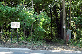
Apparently the entrance to Bonaparte's estate. We heeded the sign's direction. |
Thursday, August 9, 2012
A one-room revolution: Clara Barton in Bordentown
Having checked out the wonders of Mount Holly and done some reconnaissance on potential nearby birding sites, we decided that maybe it was time to head back home. That, however, was a short-lived plan. We'd just made it onto the Turnpike from the Pennsy Pike extension when we ran into a massive traffic jam. Rather than sitting there, we decided to exit at Interchange 7 and take our chances with Route 206.
Per Ivan's prediction, it didn't take long for us to find something interesting. As we drove down Crosswicks Street, we came upon a small building with one of those glorious blue historic markers. "Clara Barton School."
"I have a feeling we'll run into something really good," Ivan said, confidently. If past experience could be our guide, he'd be completely correct. Exit 7, of course, serves Bordentown, a place I'd long wanted to check out. The closest I'd gotten was finding out the Bonaparte connection... but never knew quite why the town would hold any interest for an exiled 'royal' family.
Per Ivan's prediction, it didn't take long for us to find something interesting. As we drove down Crosswicks Street, we came upon a small building with one of those glorious blue historic markers. "Clara Barton School."
Many don't know this, but before she became known as a leading health advocate and founded the American Red Cross, Barton was a schoolteacher. She was a Massachusetts native but came to teach in Bordentown after a visit to a friend in Hightstown. At the time, the custom was for teachers to bill students at the end of each term, a practice she sought to change in favor of a free public school supported by funding from the town. In her estimation, far too many children weren't getting an education because they couldn't afford private school tuition.
Her popularity with students and parents helped to push the idea forward, and in 1852 the town allowed her to start her new school in a one-room building that predated the Revolution. As more and more children learned about the availability of free education, the school quickly swelled to a student body of 600. More teachers and more buildings were pressed into service to manage the demand.
Unfortunately, it appears that Barton's success planted the seeds of her undoing in Bordentown. According to the Bordentown Historical Society website, a lengthy bout with laryngitis caused her to miss a few months of school, and in that time, local officials replaced her with a male principal at a salary reported to be twice what she was being paid. She was also deemed to be his assistant, a position she found distasteful. She resigned her position and moved to Washington D.C. for higher-paid employment.
Barton made an indelible impact on Bordentown and New Jersey in just over two years. She'd founded one of the first free schools in the state at a time when free education, while provided by statute, was rarely provided to any but the indigent. Children all over the state joined forces in the early 1920s to honor her work by restoring the one-room schoolhouse, and today it stands as a picturesque reminder of the dynamic woman who brought knowledge to those who might not ordinarily have had the chance to study.
Monday, August 6, 2012
Stopping by the Mill Street Hotel and Tavern
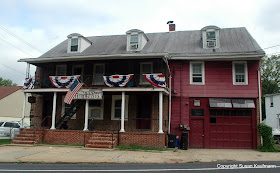
Our stroll through Mount Holly brought us to a classic part of virtually any colonial town: the inn. The Mill Street Hotel and Tavern looked the part, even without the sign hanging on the porch, stating the founding date as 1723.
The WPA Guide to New Jersey describes the place as “the last remnant of the Three Tun Tavern,” with “original brick walls, revealed in places by a crumbling coat of stucco.” During Colonial times, inns were classified by size, with the ‘tun,’ or hogshead, used as a measure of the amount of liquor there. The Guide goes on to describe a covered cobblestone drive where stagecoaches would stop before heading to the carriage yard around back.
Both the stucco and the drive are gone, the former leaving a brickface and the latter being replaced by a garage door and transom windows. While it appears that the hotel may have evolved into a rooming house, a neon Coors Light sign indicates that the bar is still in business. It was a bit too early in the day for us to check on that personally.
Initial research on the place doesn’t reveal much else, except conjecture that the British Court of Admiralty met there in the last year of the Revolution. Mount Holly was occupied from time to time during the war, and while I can’t find any information on specific judicial action there, patriots generally found Court actions objectionable. Admiralty judges were paid based on the fines they levied, so their decisions could be, well, somewhat influenced by factors other than the law.
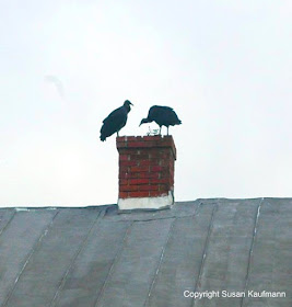
One last thing about the Mill Street Hotel and Tavern: there was something about it that drew the focused attention of some interesting raptors. In my experience, it’s fairly unusual to see a pair of black vultures peering into a chimney, but that’s what we saw. Perhaps an errant squirrel or raccoon had made its way up the roof and into the flue, expiring there when it couldn’t get out. We couldn’t quite tell, and the vultures weren’t saying a word. Maybe they're the returned spirits of the Admiralty judges?
Friday, August 3, 2012
Relief in Mount Holly: the country's oldest volunteer fire department
Walking around a town like Mount Holly makes you yearn for the days when public buildings were designed for both visual appeal and functionality. The Relief Fire Company's 1892 building on Pine Street is a case in point, a solid stone structure with a highly-decorative Victorian-style tower topped by a horn-shaped weather vane. Though the truck bay doors are obviously replacements, it's not hard to imagine that the original doors might have been of handsome wood with metal trim.
As impressive as the firehouse is, though, it's almost incidental to what makes the Mount Holly fire fighting story remarkable. THAT story is in a small red-trimmed yellow shed on the other side of the fire department driveway. It doesn't look like much, but it's the origin of the country's oldest, continually-operating volunteer fire company, founded in 1752, when the town was still known as Bridgetown.
Relief's original name was the Britannia Fire Company of Bridgetown, in recognition of its members' allegiance as British subjects. According to the Mount Holly fire website, each member was required to hang a leather bucket outside his house, and keep it filled with water and ready for use in protecting his neighbors' homes and property from fire.
The town's first water pumper truck was purchased in 1755, though the firehouse to store it wan't built until 1798. By that time, the company had changed its name to the Mount Holly Fire Company, considering "Brittania" to be both unpatriotic and anachronistic.
The small firehouse was sold in 1837 and became a toolshed for the local St. Andrew's Graveyard before being returned to the fire company and placed on its current Pine Street site. Eventually, the fire company's name was changed yet again, to Relief, and the current firehouse was built in 1892.
Visitors today can stop by the old firehouse and an adjacent shed, which houses a vintage pumper truck and other memorabilia. We weren't able to go inside, but a large window allowed us to see the contents of the museum from the sidewalk. The building isn't big or tall enough to accommodate the sliding pole or dalmatians you imagine to be part and parcel of every firehouse, but it offers an interesting view into what firefighting was like back in the day.
Wednesday, August 1, 2012
Mount Holly: more old stuff than you can shake a stick at
Many years of schooling and work in New Jersey have resulted in the happy consequence of needing to visit various parts of the state for personal and business reasons. That's what brought me to Mount Holly for the first time several weeks ago. I didn't have time to do much exploring on that initial visit, but I knew I'd have to make a return trip with Ivan. That's what we did one day this past weekend.
From my trip to Burlington, I knew that it was a good sign that the main road into town is High Street. Maybe it comes from the old British custom of calling a community's primary artery 'the high street,' I don't know, but it's brought me luck on the exploring end in South Jersey.
Driving into town from the Turnpike, it wasn't long before we were greeted by the view of several 18th and 19th century homes and commercial buildings on either side of the road. It was only about 10 a.m., so parking was a breeze. Somehow I didn't even notice that I was setting the car by the curb right in front of the Burlington County Prison. Very old (built in 1810) and looking a bit foreboding, it was designed by Robert Mills, the same architect as the Washington Monument.
I was reading the sign that outlines the building's history when I heard a voice behind me.
"You been in there?" I turned to find a woman walking her dog. Uh, no, not yet. It wasn't likely during that visit, either, as the museum wasn't to open until noon. A visit for another day.
"You know, it's haunted!" she said. Come to think of it, I'd heard about that, but ghosts aren't really our interest at Hidden New Jersey. The woman went on to tell me that her daughter claimed her house was haunted, as well. "The ghost ever cause any problems?" I asked. Nope. What's the problem then? Live and let live (or unlive, I guess), I say.
The county courthouse is next door to the prison, conveniently, small but stately with a New Jersey seal and the date 1796 above the door. It was built after the county seat was moved there from Burlington, and it's holding up quite nicely with the years. In fact, some consider its Georgian design to be one of the country's best examples of preserved eighteenth-century architecture.
Of course, we can't go to a county seat without checking for a meridian marker. You might remember that we first discovered these aids to survey calibration at the Hunterdon County Courthouse in Flemington, but we've come up short every time we've looked elsewhere. There was nothing on the High Street side of the Burlington Courthouse; perhaps the rear of the building would be more fruitful? It didn't take long for me to locate the first marker, though its veracity is in question. While the location's longitude and latitude are presumably those that are engraved in the granite obelisk, the brass disc on top was partially covered with a duct tape strip that had other numbers scrawled on it with an indelible pen. In any case, the companion marker was a bit more difficult to find, given that it was sequestered hard against another building, next to the natural gas meter.
From there, we walked farther down High Street, following the very helpful historic district directional signs. What to visit next? My curiosity was piqued by the words "Log Cabin." You don't get many chances to visit old log cabins in New Jersey, so we definitely had to check that one out.
We followed the sign's arrow behind some of the buildings facing High Street, down through a parking lot and across a stream to find a small cabin... with storm windows. Only in New Jersey: an energy efficient 18th century domicile. Oh, and a sign directly in front, saying "Log Cabin Parking Only."
There's no interpretive signage nearby, nor was there any information in my WPA Guide, so we didn't learn the story of the cabin until we got home. Known as the Shinn Curtis Log House, it was built around 1712 and went through so many additions and build upons that it wasn't really discovered to exist in modern times until the house surrounding it was demolished in 1967. I guess that wasn't entirely unusual back in the day -- we heard a similar story about the Perth Amboy City Hall when we visited last year. In any case, the Curtis family lived there for nearly 150 years, starting in 1802. (You can see a photo of its mid-20th century pre-demolition condition here.)
There's a lot more to our Mount Holly visit, which we'll cover in future posts. Suffice to say, we uncovered a lot!
From my trip to Burlington, I knew that it was a good sign that the main road into town is High Street. Maybe it comes from the old British custom of calling a community's primary artery 'the high street,' I don't know, but it's brought me luck on the exploring end in South Jersey.
Burlington County Courthouse. Very stately! |
I was reading the sign that outlines the building's history when I heard a voice behind me.
"You been in there?" I turned to find a woman walking her dog. Uh, no, not yet. It wasn't likely during that visit, either, as the museum wasn't to open until noon. A visit for another day.
"You know, it's haunted!" she said. Come to think of it, I'd heard about that, but ghosts aren't really our interest at Hidden New Jersey. The woman went on to tell me that her daughter claimed her house was haunted, as well. "The ghost ever cause any problems?" I asked. Nope. What's the problem then? Live and let live (or unlive, I guess), I say.
The county courthouse is next door to the prison, conveniently, small but stately with a New Jersey seal and the date 1796 above the door. It was built after the county seat was moved there from Burlington, and it's holding up quite nicely with the years. In fact, some consider its Georgian design to be one of the country's best examples of preserved eighteenth-century architecture.
Ivan waves from one of the meridian markers. I took this picture from the other. |
From there, we walked farther down High Street, following the very helpful historic district directional signs. What to visit next? My curiosity was piqued by the words "Log Cabin." You don't get many chances to visit old log cabins in New Jersey, so we definitely had to check that one out.
The Shinn-Curtis Log House. Parking in front is reserved for visitors. |
There's no interpretive signage nearby, nor was there any information in my WPA Guide, so we didn't learn the story of the cabin until we got home. Known as the Shinn Curtis Log House, it was built around 1712 and went through so many additions and build upons that it wasn't really discovered to exist in modern times until the house surrounding it was demolished in 1967. I guess that wasn't entirely unusual back in the day -- we heard a similar story about the Perth Amboy City Hall when we visited last year. In any case, the Curtis family lived there for nearly 150 years, starting in 1802. (You can see a photo of its mid-20th century pre-demolition condition here.)
There's a lot more to our Mount Holly visit, which we'll cover in future posts. Suffice to say, we uncovered a lot!